

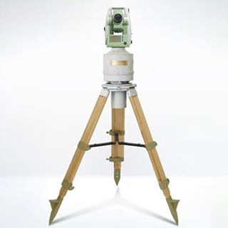
Land Survey
")
Land Survey Overview
Soil requirements in span construction require accurate soil measurements and soil maps to demonstrate bridge design and construction. Surveyors use advanced equipment such as total stations and GPS to determine elevations, maps and property boundaries. This information helps engineers understand the structure of the terrain, identify potential obstacles, and choose the best bridge design. Additionally, soil testing ensures compliance with regulatory requirements and minimal environmental impact. Accurate ground surveys are essential for successful bridge construction, provide critical information for planning, design and site preparation, and ultimately contribute to the safety, efficiency and sustainability of infrastructure development the wor
Geotechnical surveys in span construction involve accurate mapping of the terrain using all stations and GPS to report bridge construction, ensure alignment, compliance and minimize interference we are surrounded by it.
Land Survey Challenge
Ground surveys present many challenges in span construction. Accurate landscaping requires navigation over rugged terrain, dense vegetation, and water resources, and often needs specialized equipment and access can be done in remote or dangerous areas dense, and requires elaborate design and security measures. Additionally, surveyors must contend with adverse weather conditions, which can affect data collection and equipment performance. Accurately interpreting survey data is another challenge, as it does not immediately reflect complex soil features or subsurface obstacles Integrating survey data into engineering design software and ensuring consistency can take more time and requires specialized knowledge.
Additionally, land surveying in urban areas presents unique challenges, such as navigating narrow streets, coordinating with property owners, and obtaining the necessary permits and owing the necessary permits careful consideration of habitat safety and compliance is essential for research in environmentally sensitive areas. Furthermore, accurate surveys over long distances can be difficult, especially for projects involving wide geographic areas. Factors such as soil curvature and magnetic interference can affect measurements and require adjustments and quality checks. Overall, solving these soil survey challenges requires collaboration among soil surveyors, engineers and project stakeholders, as well as the adoption of advanced technologies and innovative approaches ensure accurate and reliable data collection for successful span construction